 Prior to the first Mixing Zephyr cruise,
Rick Thomson of the Institute of Ocean Sciences
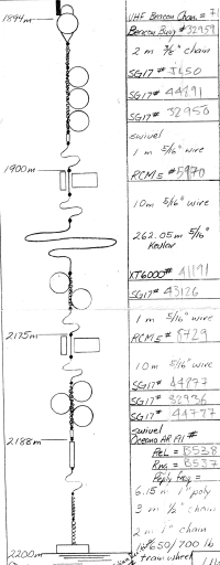
sucessfully deployed a dual current meter mooring
(sketched at right; click on it to see enlarged version).
The mooring supported two meters,
25 and 300 meters above the bottom and was located ~200 meters
ENE of the Main Endeavour Vent Field (dropped at ). Since the
seafloor there is at a depth of 2200 meters, the depths of the
two meters was ~2175 and ~1900 meters, respectively.
Prior to the first Mixing Zephyr cruise,
Rick Thomson of the Institute of Ocean Sciences
sucessfully deployed a dual current meter mooring
(sketched at right; click on it to see enlarged version).
The mooring supported two meters,
25 and 300 meters above the bottom and was located ~200 meters
ENE of the Main Endeavour Vent Field (dropped at ). Since the
seafloor there is at a depth of 2200 meters, the depths of the
two meters was ~2175 and ~1900 meters, respectively.60 days of data were received by the UW from the IOS, and were collected between 24 May and 23 July (Julian days 144.049-204.132). Good data begin at Julian day 149.04861 = June 29 1:10 UTC, about the time that the meter was deployed and on the seafloor.
For comparison, the dates of the two cruises were:
Leg I
Atlantis II/Voyage 132/Leg 08
May 25-June 19, 1995
First Tow: May29 Julian day 149
Last Tow: June16 Julian day 167
Leg II
Atlantis II/Voyage 132/Leg 13
September 15-28, 1995
This indicates that we have current measurements only during the first Mixing Zephyr cruise.
www.geolab.nrcan.gc.ca/cgi-bin/geomag/MIRP/run_mirp suggests that
the magnetic declination in 1995 was
20o 32' E of N at latitude 047o 57' N and longitude 129o 06' W
UW 1900 010 124 595UTC 0 0.0N 0 0
.0WSTrXV 5970 10 0 8653 6 0.000
> notes on above lines:
> 1900 is height off bottom
> 9 digits before UTC are reverse time/date
> 5970 is the serial number of the current meter
> 8653 is number of records
5970/UW Vent 95
salinity temp cond. exp. t direc speed
(ppt) (c) (c) (true n) (m/s)
(12F10.3)
22.227 81750.992 0.567 7.602 319.381 0.017
...
35.471 1.967 0.745 1.982 248.608 0.218
35.471 1.967 0.745 1.982 226.350 0.192
35.471 1.944 0.745 1.982 204.499 0.112
35.471 1.944 0.745 1.982 189.030 0.077
35.471 1.967 0.745 1.982 191.491 0.237
35.471 1.944 0.745 1.982 188.679 0.205
35.471 1.944 0.745 1.982 184.811 0.108
35.471 1.967 0.745 1.982 187.975 0.037
...
--SRV
MORP Home | Mixing Zephyr Home | Search the Mixing Zephyr Pages
The Mixing Zephyr Pages
Maintained by Russ McDuff (mcduff@ocean.washington.edu)
Copyright (©) 1995,1996 University of Washington; Copyright Notice