The Mixing Zephyr Pages
CTDT Groundtruth Opportunities
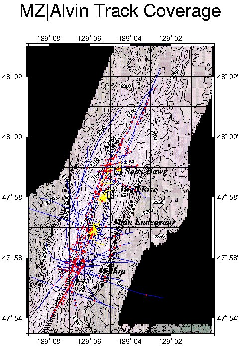
Overall Coverage of the Mixing Zephyr Night and Alvin Programs
This first map shows the traces of the all Mixing Zephyr (MZ) CTDT casts
in blue, overlain by all of the MZ Alvin dive tracks in yellow. Along
each CTDT trace, the locations where the CTDT instruments were within
50 meters of the local sea floor are highlighted in red.
Notice that because the ALVIN submersible usually descends and ascends directly upon a
dive target -- historically (during the MZ cruises?) a particular
vent field (initially located via CTDT surveys) -- very few ALVIN tracks transgress
the perimeters of the known vent fields. This means that few
observations of what the sea floor is like between known fields were obtained
via Mixing Zephyrs dive program.
Diffuse Flow Sites: Cirque and Dune
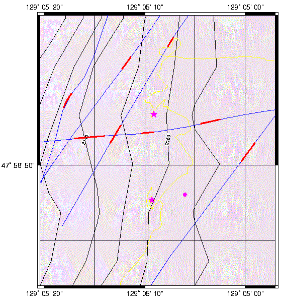
Alvin Dive 2931
is an exceptional dive in that one of its targets -- located based on near-bottom CTDT
measurments -- was hypothesized to be associated with diffuse
flow, rather than a focussed source of hydrothermal effluent.
Impressively, near the target divers encountered two areas of diffuse flow
venting through tube worm beds atop N-S basaltic pillow ridges, located about 1 km
west of the Salty Dawg vent field.
In retrospect, the sea floor observation of diffuse flow at a location
specified on the basis of CTDT information is rather remarkable, and certainly
unprecedented. Since the cost of locating and mapping potentially-extensive areas via
submersible is discouraging, it is worth re-examining the
Mixing Zephyr CTDT casts that traversed near where the
diffuse flow was observed. In turn, the ALVIN dive 2931 observations
of diffuse flow separated from known fields of hydrothermal activity represent
one of the best opportunities in all of the MZ data to "groundtruth" the CTDT
measurements. This map shows dive 2931 proceeding generally from south to north. The
first dive target -- the location of suspected diffuse flow -- is indicated by a
magenta dot, while the locations of the 2 observed areas of diffuse flow are indicated
by magenta stars. One area has been named "Cirque" and the other "Dune."
Name	X	Y	Longitude		Latitude 		Depth	Water Samples
Cirque?	5878    9562	129.085912765213	47.9799124134209	2131	GT Yellow; M Yellow;
Dune?	5882    9738	129.085859274975	47.9814955743456	2127	GT Purple; M Red;
 What exactly is the evidence of diffuse effluent in the CTDT data? How does the
signature of diffuse flow differ from the CTDT signals caused by focussed hydrothermal
flow, or can they not be differentiated without further (chemical) information? Where else in
the MZ CTDT observations are similar near-bottom signatures observed? Or is all of the
water near the seafloor (or in the Cirque-Dune depth range) marked by similar T,S,Z
characterisics?
What exactly is the evidence of diffuse effluent in the CTDT data? How does the
signature of diffuse flow differ from the CTDT signals caused by focussed hydrothermal
flow, or can they not be differentiated without further (chemical) information? Where else in
the MZ CTDT observations are similar near-bottom signatures observed? Or is all of the
water near the seafloor (or in the Cirque-Dune depth range) marked by similar T,S,Z
characterisics?
MORP Home | Mixing Zephyr Home | Search the Mixing Zephyr Pages
The Mixing Zephyr Pages
Maintained by Russ McDuff (mcduff@ocean.washington.edu)
Copyright (©) 1995,1996 University of Washington; Copyright Notice
Content Last Modified 7/17/97 SRV
Page Last Built 7/17/97